
|
 02 May 2017, 13:53
|
#1 |
|
Registered User
Join Date: Aug 2014
Location: Brindisi (Italy)
Age: 70
Posts: 8,248
|
MUIMapparium
 Author: Marcus Sackrow MUIMapparium is a OpenStreetMap.org Viewer for all Amiga Systems with Waypoints/Tracks/Routes Loading/Saving creation. Requirements all Systems RTG Graphics card (Picasso 96 or CGFX) 15/16/24/32 bit Screen TCP/IP Stack (Internet connection) 8+ MB RAM Supported Amiga-systems Amiga 68k, 68020+, (68881+ FPU recommended) AmigaOS 3.0+ Amiga OS4, OS 4.0+ AROS i386, ABIv0 AROS ARM, ABIv0 ARMV6+ VFPV2+ HardFloat (e.g. RasPi 1-3) AROS x86_64, ABIv1 (non SMP-Version) MorphOS 3.8+ Additional Notes The FPU version is much faster, especially with routes and tracks. If you experience slow map movement, with the NoFPU version, don’t blame me (or the program) buy a proper FPU. With Vampire (at least until Gold 2.9) you have to use the NoFPU-Version of MUIMapparium. The Vampire FPU is not IEEE754 compatible and therefore does not work with MUIMapparium. Offline Operation is possible, but only harddisk cached map images MUIMapparium v0.6: Download MUIMapparium Tutorial Video [ Show youtube player ] Last edited by AMIGASYSTEM; 06 May 2020 at 07:00. |

|
|
10 July 2017, 09:00
|
#2 |
|
Registered User
Join Date: Aug 2014
Location: Brindisi (Italy)
Age: 70
Posts: 8,248
|
Changes:
MUIMapparium v05: All OS Download Example GPX with a Track, a Route and some Marker Download Last edited by AMIGASYSTEM; 10 July 2017 at 09:28. |
|
|
|
10 July 2017, 11:53
|
#3 |
|
Registered User
Join Date: Oct 2014
Location: Klagenfurt / Austria
Posts: 1,559
|
nice map viewer!
is it possible to change destination folder for downloaded map tiles? |
|
|
|
10 July 2017, 15:28
|
#5 | |
|
Registered User
Join Date: Oct 2016
Location: Berlin
Posts: 52
|
Quote:
Define Directory for Images via ToolTypes: e.g. DATADIR=DH1:TmpDir Open the Icon Information for MUIMapparium and add a Tooltype DATADIR=DH1:TmpDir replace DH1:TmpDir by the directory you want to use for the images. |
|
|
|
|
10 July 2017, 16:06
|
#6 |
|
Registered User
Join Date: Oct 2014
Location: Klagenfurt / Austria
Posts: 1,559
|
i tried that tooltype (in my case dh3:misc/mapdata) but it didn't work.
i tried following variations: DATADIR=DH3:misc/mapdata DATADIR="DH3:misc/mapdata" "DATADIR=DH3:misc/mapdata" also even if i delete data folder in program folder, no difference. a new data folder is created and all map tiles are stored within. i ended up moving the entire program folder to dh3:misc location. btw. how can i make routes, etc? didn't figure it out yet. currently i only can make waypoints on the map but no routes. if i add route in routes tab, name it and save, nothing happens. no route has been added, routes tab is still empty. on path tab there is no "add" button at all. how to make path? as long this path tab remains empty, the edit button is useless... and how can i set sidebar and stats window to be visible at start? |
|
|
|
10 July 2017, 16:20
|
#7 | |||
|
Registered User
Join Date: Oct 2016
Location: Berlin
Posts: 52
|
Quote:
Which system do you use? (Amiga OS3.x, OS4, AROS, MorphOS) I only tried that on AROS currently. Oh I see it should be DATAPATH=DH3:misc/mapdata uhh big error in changelog  sorry sorry  Quote:
Thanks for the feedback. |
|||
|
|
|
10 July 2017, 17:17
|
#8 | ||||
|
Registered User
Join Date: Oct 2014
Location: Klagenfurt / Austria
Posts: 1,559
|
Quote:
Quote:
Quote:
don't worry about time. it's finished when it's finished... Quote:
|
||||
|
|
|
01 October 2017, 22:37
|
#9 |
|
Guru Meditating
Join Date: Jun 2014
Location: England
Posts: 2,337
|
Could you make an os3.9 PowerPC version?
|
|
|
|
02 May 2018, 00:11
|
#10 |
|
Registered User
Join Date: Aug 2014
Location: Brindisi (Italy)
Age: 70
Posts: 8,248
|
MUIMapparium v0.6 Update
|
|
|
|
02 May 2018, 13:14
|
#11 |
|
Registered User
Join Date: Oct 2014
Location: Klagenfurt / Austria
Posts: 1,559
|
nice, now stats windows stays open, thank a lot! i wish, i could also leave sidebar open and save its width!
how can i change order of waypoints in list? moving a waypoint up/down by mouse doesn't seem to work. how can i set start location? map position always centers berlin at start, which is not my home location... and different colours for waypoints would be a nice feature too! Last edited by honx; 02 May 2018 at 15:48. |
|
|
|
02 May 2018, 17:15
|
#13 |
|
Registered User
Join Date: Oct 2014
Location: Klagenfurt / Austria
Posts: 1,559
|
i'd rather wait until he comes back here and reads this thread again.
because i don't want to register again in yet another board... |
|
|
|
03 May 2018, 08:55
|
#14 | |
|
Registered User
Join Date: Oct 2016
Location: Berlin
Posts: 52
|
Quote:
leave sidebar open did not work as expected... Thats the reason I left it out... I have to work on it a bit more (some MUI strange behavior) same with the width, that is nothing I can influence, MUI handle that. yeah the start location, I just forget the prefs window entry for it  you can add it by hand of course to the prefs Open MUIMapparium.prefs (in the same folder) with a text editor and add a section "[General]" if not already there and add the two entries StartLan,StartLon with the longitude and latitude of the start point (you can read from a waypoint for example) with a point as decimal separator for example: Code:
[General] StartLat=14.5 StartLon=18.6 Thanks |
|
|
|
|
03 May 2018, 16:38
|
#15 |
|
Registered User
Join Date: Oct 2014
Location: Klagenfurt / Austria
Posts: 1,559
|
thx, setting start position works!
is it also possible for main map window to stay focused, also if stats window remains open on startup? would be nice feature too! and what exactly can i do with "paths" tab? never found out how to use it. |
|
|
|
03 May 2018, 20:34
|
#16 |
|
Registered User
Join Date: Oct 2016
Location: Berlin
Posts: 52
|
maybe I have to check.
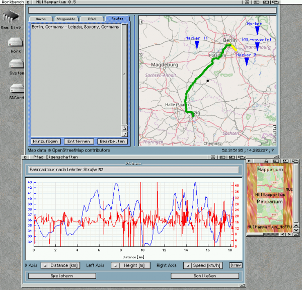
Pathes? you mean Tracks (Pfad in german)? hmm that means you didn't find the main reason I made that Program. ;-) Thats GPS recorded travels. You can load different kind of files recorded by GPS devices (or mobiles this days) GPX is most common, but also KML/KMZ is rather often used (by google earth for example) and FIT (Garmin) is possible. I use MUIMapparium mainly to inspect my bicycle travels ;-) which I recorded with my iPhone. (Motion GPS, or Komoot) To have an idea how that looks like use the TracksnMarker.lha I supplied on the MUIMapparium page, there is a Track included which you can look at try also "Edit" to get the plot like shown on the screenshot on MUIMapparium page. Watch this Video [ Show youtube player ] it's from Mapparium, but MUIMapparium works comparable. have fun |
|
|
|
03 May 2018, 21:04
|
#17 |
|
Registered User
Join Date: Oct 2014
Location: Klagenfurt / Austria
Posts: 1,559
|
thx, i never worked with gps devices, so i didn't know about.
i downloaded the file and loaded it. now i'm playing with it. another question: is it possible to rename "current position" in routes tab? |
|
|
|
16 May 2018, 19:36
|
#18 |
|
Registered User
Join Date: Oct 2016
Location: Berlin
Posts: 52
|
ATTENTION:
Currently the Search function is broken, because the service used for it changed to SSL only which is not supported by MUIMapparium at the moment. I will work on this the next days, so wait for 0.7 to fix that. and because there is an error in the source MUIMapparium will crash instead of printing the errorcode The routing function is also affected by this of course. Sorry. |
|
|
|
18 May 2018, 19:33
|
#19 |
|
Registered User
Join Date: Oct 2016
Location: Berlin
Posts: 52
|
MUIMapparium 0.7
As announced yesterday I release today the new version of MUIMapparium. It's 0.7 now, most important features are the repaired Search function, Exports and the PhotoList Change List:
I added some debug output at AmigaOS4, so if you experience problems starting up MUIMapparium on OS4 check the debug output (e.g. Sashimi) it should count from 1 to 26 on the program start, check if any numbers missing and send me the result on one of the forums I'm usually on. |
|
|
|
18 May 2018, 21:08
|
#20 |
|
Registered User
Join Date: Oct 2014
Location: Klagenfurt / Austria
Posts: 1,559
|
this i call progress! nice!
but setting a route is buggy. first route leads from current position (hm) in klagenfurt to mainz, which is almost perfect. because of first route being displayed in english i wanted do draw the same route again after i set language to german. it should also lead from current position (hm) in klagenfurt to mainz. but current position isn't current position anymore. it's more north, see start of green route. green route should be identical to blue route as it should start at same positon. coordinates are still the same as current positon (hm) but the start point is off by a huge distance towards north. colours don't fit either for second route. light blue colour is selected, but second route with wrong start is green. and searching within route making window doesn't work for me. i can only do current position to current position. would be nice being able to select predefined waypoints as start and end position of the route... Last edited by honx; 18 May 2018 at 21:13. |
|
|
| Currently Active Users Viewing This Thread: 1 (0 members and 1 guests) | |
| Thread Tools | |
|
|


